Oh, hello, nice to meet you!

I Am Seth Frame

Making maps out of your Dreams1...

About me

Seth Robert Frame, GISP

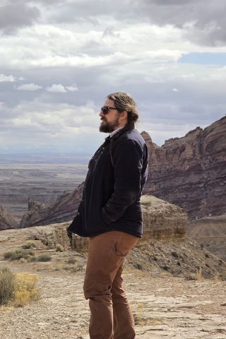
Raised in the Middle West, Seth Frame has over a decade of experience in GIS; most of that time has been spent in cultural resource management. In a previous life, he performed GIS services for archaeological companies in the intermountain West, he now lives in upstate New York where he is employed as a GIS Supervisor/Analyst for a software development company. Seth is the proud Papa to two fine boys: Lorenzo and Domenico. He has also somehow managed to receive a Bachelor of Arts degree in anthropology from Colorado State University and a degree from the University of Wisconsin-Madison's Cartography and Web Mapping Masters program. Both degrees were obtained while being employed full-time.

Resume

QUALIFICATIONS

+ ESRI ArcDesktop Software 10.x

  • ArcPro 2.x
  • ArcGIS Online
  • ArcGIS Enterprise
  • 3D Analyst Extension
  • Spatial Analyst Extension
  • Network Analyst Extension
  • Data Interoperability Extension
  • Arcpy
  • ArcGIS API for JavaScript

+ Trimble Software and Hardware

  • Pathfinder Office Software
  • GeoExplorer XT GPS Units (2005, 3000, 6000, and 7x models)
  • TerraSync Software
  • TerraFlex ArcGIS Add-In and InSphere
  • Python
  • C#
  • Java
  • JavaScript
  • JQuery
  • AJAX
  • Leaflet
  • D3
  • PostgreSQL
  • Microsoft SQL Server
  • RDBMS
  • DBA
  • ArcSDE
  • HTML
  • CSS
  • Microsoft Office Suite
  • Microsoft Teams
  • Adobe Creative Suite
  • Mapbox
  • Google Earth
  • ChatGPT & Bard

WORK HISTORY

+ GIS Supervisor/Analyst, Tyler Technologies, Latham, NY
  • Supervised and mentored a team of GIS Specialists
  • Troubleshot client software issues
  • Created advanced Python script tools to process data
  • Quality checked GIS data ensuring proper network routing
  • Created and deployed geocoding services
  • Automated routine tasks with custom Python script tools

Aug. 2016 – Present

Achievement:
Increased communication between the departments by creating an internal tracking website. The site streamlines the project management process by visualizing project status, assignments, and estimated completion dates.

+ GPS/GIS Specialist, Landmark Archaeology, Altamont, NY
  • Collected GPS data of archaeological survey
  • Created maps used for navigation and client deliverables
  • Performed archaeological survey and excavation

June 2016-Aug.2016

Achievement:
Decreased data collection time in the field with the recommendation of an upgrade to the GNSS receiver being used. By upgrading, the time spent in collecting data in the field was reduced by 50%. This allowed for an increase in the amount of data collected during the day

+ GIS Lab Supervisor, Alpine Archaeological Consultants, Montrose, CO
  • Performed predictive modelling for use in federal lands management
  • Conducted viewshed analysis to determine visual impacts to archaeological sites
  • Produced maps using raw data for field use and finished reports
  • Coordinated the GIS lab to work as a team
  • Created artifact illustration, site reconstruction figures, and report cover graphics

Nov. 2009- June 2016

Achievement:
Improved efficiency by creating a python script tool that creates archeological site maps. The tool creates a rough draft of a site map in a manner of moments. This led to a 30% increase in efficiency by automating the process of taking field data and producing a rough draft map.

+ Archaeological GIS Specialist, Western Land Services, Sheridan, WY
  • Initiated and maintained GPS data collection protocols
  • Produced maps from raw data for field use and finished maps for use in reports
  • Collected field data using the Trimble GeoXT, Garmin eTrex, and Rhino 530 GPS units
  • Assisted and instructed the archaeology staff on the use of GPS units and software
  • Performed mapping duties for other departments as needed

Aug. 2005-April 2009

+ GIS Coordinator, St. Joseph County Auditor's Office, South Bend, IN
  • Maintained digital parcel data
  • Produced plat maps and variances for the public
  • Entered property ownership information into the Auditor’s computer records system
  • Represented the Auditor's office at county GIS board meetings
  • Collaborated with other departments to collect and share digital data

May 2004 – July 2005

+ ADDITIONAL EXPERIENCE

Blue Door GIS, Scripting Consultant, Ridgway, CO

  • Produced custom Python script tools

National Audubon Society Marine Drive Park Project, Volunteer, Montrose, CO

  • GPS/GIS Specialist

EDUCATION

Master of Science, Cartography and GIS
University of Wisconsin - Madison
Aug. 2017 - Aug. 2018

Bachelor of Arts, Anthropology
Colorado State University, Summa Cum Laude
Aug. 2014 - Dec. 2016

Associate of Arts
Southwestern Michigan College
Aug. 2002 - April 2005

+ CERTIFICATIONS/TRAININGS

GIS Professional (GISP), GIS Certification Institute, June 2019

#Leadwell: Building Leaders for Tomorrow, Bishop House Consulting, Dec. 2017
Management Training

ESRI Technical Certification ArcGIS Desktop Associate 10.1, Dec. 2013

Trimble Systems Training, Electronic Data Solutions, May 2007

+ ORGANIZATIONS

Front Range Community College, Geospatial Science Advisory Board Member, Dec. 2021 – Present

Minnesota GIS/LIS Consortium, Feb. 2021 – Present

New York State GIS Association, Professional Development Committee Member, Jan. 2016 – Present

Geospatial Information System and Mapping Organization, Jan. 2016 – Present

GIS Colorado May 2013 – Present

Colorado Council of Professional Archaeologists, Mar. 2010 – Present

Contact

Thanks for perusing my site. Please feel free to contact me with any questions or comments you may have. You can also connect with me via LinkedIn. Links to both can be found below.

1Adebimpe, Tunde, TV on The Radio, "Young Liars", Young Liars, EP, Touch and Go, 2003

2Orzolek, Karen Lee, Yeah Yeah Yeahs, "Maps", Fever to Tell, Studio Album, Interscope, 2003

>